Introduction
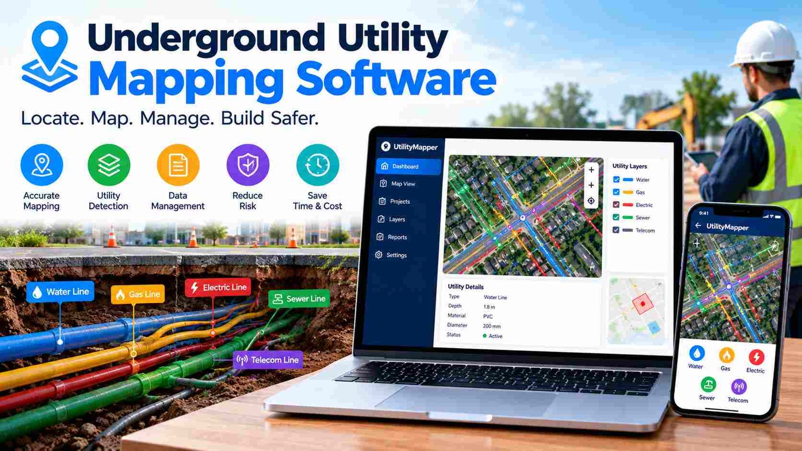
Underground utility mapping software is a digital solution that helps engineers, contractors, surveyors, and utility companies locate, record, and manage underground infrastructure. It creates accurate maps of buried assets such as water pipes, gas lines, electrical cables, fiber optics, and sewer networks using GIS, GPS, and surveying technologies. These digital maps are essential for planning safe excavation and reducing costly mistakes.
Before any construction or digging project begins, knowing what lies beneath the ground is critical. Outdated paper drawings, incomplete utility records, and manual mapping methods often lead to utility strikes, project delays, and expensive repairs. A single damaged pipeline or communication cable can interrupt public services and increase project costs significantly.
Modern underground utility mapping software replaces paper records with intelligent digital maps that can be updated in real time. By combining field survey data with Geographic Information Systems (GIS), organizations improve accuracy, collaboration, and long-term asset management. In this guide, you will learn how underground utility mapping software works, its key features, major benefits, the best software solutions available, and how to choose the right platform for your projects.
What Is Underground Utility Mapping Software?
Underground utility mapping software is specialized mapping technology designed to identify, visualize, and manage buried infrastructure. Unlike ordinary digital maps that mainly show roads and buildings, this software focuses on hidden assets below the surface. It stores precise location data together with valuable information such as pipe size, material, installation date, ownership, and maintenance history.The software creates layered digital maps where every utility type is displayed separately, making it easier to analyze underground networks without confusion.
How does it differ from regular mapping software?
Traditional mapping applications are built for navigation or basic geographic visualization. Underground utility mapping software goes much further by integrating surveying equipment, GPS receivers, CAD drawings, and GIS databases into one workflow. It supports engineering accuracy rather than simple location viewing and allows professionals to update utility records directly from the field.
Industries that use it
Many industries depend on underground utility mapping software. Construction companies use it before excavation, while civil engineers design roads and infrastructure around existing utilities. Utility providers manage water, gas, and electricity networks, and municipal governments maintain public infrastructure. Telecommunications companies map fiber optic cables, while oil, gas, and sewer authorities rely on accurate underground records for maintenance and expansion projects.
How Underground Utility Mapping Software Works?
Creating reliable underground maps involves several connected stages, from field detection to cloud collaboration. This digital workflow helps organizations maintain accurate utility records throughout the asset lifecycle.
Step 1 – Utility detection and data collection
The process begins with locating underground utilities using professional survey equipment. Ground Penetrating Radar (GPR) detects buried objects by sending radar signals into the ground, while electromagnetic locators identify conductive cables and pipelines. Surveyors also use GPS and GNSS receivers to capture highly accurate coordinates, often supported by total stations for engineering-grade measurements. In larger infrastructure projects, LiDAR may be used alongside surface surveys to improve overall spatial accuracy.
Step 2 – Data processing
After field collection, the information is processed inside GIS software. Survey points are converted into standardized coordinate systems, georeferenced to real-world locations, and checked for errors. Duplicate records and conflicting measurements are removed to create a clean, reliable database that supports future maintenance and planning.
Step 3 – Creating digital utility maps
The processed data is organized into GIS layers, where each utility type receives its own visual category. Water, sewer, gas, electricity, and communication lines are displayed using color-coded symbols and detailed asset attributes. Engineers can quickly identify buried infrastructure, analyze utility conflicts, and generate professional maps for construction projects.
Step 4 – Sharing and updating maps
Modern platforms store utility maps in the cloud, allowing office teams and field crews to access the same information. Changes made during inspections automatically synchronize across devices, while version control preserves previous records and ensures every stakeholder works with the latest utility data.
Types of Underground Utilities That Can Be Mapped
Underground utility mapping software supports a wide range of buried infrastructure, helping organizations build complete digital asset inventories.
Water pipelines are among the most frequently mapped assets. Accurate records help utility providers detect leaks, schedule maintenance, and plan network expansions without damaging existing pipes.
Sewer systems require detailed mapping because they include gravity pipes, manholes, inspection chambers, and wastewater connections. Digital records improve maintenance planning and reduce service disruptions.
Stormwater drains collect rainwater and prevent flooding in urban areas. Mapping drainage networks allows engineers to design better road systems and identify blocked or damaged sections during inspections.
Gas pipelines demand extremely accurate location records because accidental damage can create serious safety hazards. Utility mapping software helps contractors avoid gas lines during excavation and supports emergency response planning.
Electrical cables include both low-voltage and high-voltage underground networks. Digital mapping reduces accidental cable strikes and assists utility companies with maintenance scheduling.
Fiber optic cables form the backbone of modern communication infrastructure. Telecommunications providers rely on precise underground maps to expand broadband services while protecting existing connections.
District heating lines transport heated water beneath cities in many regions, while communication conduits carry multiple cables inside protective ducts. Mapping these systems creates a complete view of underground infrastructure and simplifies future construction planning.
Key Features of Underground Utility Mapping Software
The value of underground utility mapping software comes from its ability to combine surveying, GIS, asset management and collaboration into one connected platform.
Modern software includes advanced GIS mapping tools that organize utilities into separate spatial layers for easier analysis. Engineers can visualize multiple infrastructure networks simultaneously without creating cluttered drawings. These GIS capabilities also support spatial analysis, helping identify conflicts between planned construction and existing utilities.
GPS and GNSS integration allows field crews to capture highly accurate coordinates directly from survey equipment. This eliminates manual data entry and improves the precision of underground records. Many solutions also support CAD import and export, making it simple to exchange engineering drawings in formats such as DWG while maintaining compatibility with GIS databases.
Another important feature is 3D underground visualization, which gives engineers a better understanding of utility depth and spatial relationships. Instead of viewing pipelines as flat lines, teams can analyze complex underground environments from multiple perspectives.
Field productivity improves through mobile data collection, where inspectors record photos, measurements, notes, and asset conditions using tablets or smartphones. Cloud storage ensures this information is immediately available to office staff, while real-time collaboration keeps everyone working with the latest map version.
Additional features such as automated reporting, documentation, asset maintenance records and offline field access make underground utility mapping software practical even in remote locations without internet connectivity.
Major Benefits of Underground Utility Mapping Software
Organizations invest in underground utility mapping software because it improves safety, efficiency and long-term infrastructure management across every stage of a project.
Improves excavation safety
The greatest benefit is safer excavation. Accurate utility maps help contractors identify buried infrastructure before digging begins, reducing the likelihood of damaging gas, water, or electrical networks. This protects workers, nearby communities, and critical public services.
Reduces utility strikes
Utility strikes often happen because buried assets are missing from outdated records. Digital GIS databases provide current, verified information that significantly lowers the risk of accidental damage during construction and maintenance work.
Increases survey accuracy
By combining GPS, GNSS, GPR, and professional surveying equipment, organizations create highly accurate underground records. Better accuracy leads to better engineering decisions and fewer unexpected discoveries during excavation.
Saves project time
Field crews spend less time searching for utility information because everything is stored in one centralized digital system. Faster access to accurate data speeds up planning, permitting, inspections, and construction activities.
Lowers construction costs
Avoiding damaged utilities prevents expensive repairs, legal claims, project delays, and emergency service interruptions. Even small improvements in mapping accuracy can generate significant cost savings over large infrastructure projects.
Simplifies regulatory compliance
Many municipalities require documented utility records before approving construction. Underground utility mapping software helps organizations produce professional reports, maintain inspection histories, and meet regulatory documentation requirements more efficiently.
Better asset lifecycle management
The software also supports long-term infrastructure management by storing maintenance history, inspection dates, repair records, and asset conditions in one searchable database.
Best Underground Utility Mapping Software Solutions
Different projects require different software. Some organizations prioritize enterprise GIS, while others focus on field inspections or engineering design. The best underground utility mapping software depends on workflow, budget, and technical requirements rather than one universal solution.
ArcGIS Pro
Ideal for enterprise GIS, advanced spatial analysis, and 3D infrastructure mapping.
ArcGIS Utility Network
Designed for utility providers managing complex network topology, connectivity, and tracing.
AutoCAD Map 3D
Strong choice for engineers who combine CAD drawings with GIS data and DWG workflows.
QGIS
Popular open-source option offering powerful GIS tools and customizable plugins for budget-conscious teams.
Fulcrum
Excellent for mobile inspections, GPS data capture, and real-time synchronization between field and office.
PointMan
Built specifically for utility locating, as-built mapping, and exporting accurate GIS-ready records.
Comparison Table of Popular Software
| Software | Best For | Mobile | GIS | CAD |
| ArcGIS Pro | Large utility organizations | Yes | Yes | Yes |
| ArcGIS Utility Network | Utility asset management | Yes | Yes | Limited |
| AutoCAD Map 3D | Civil engineers | Yes | Yes | Excellent |
| QGIS | Budget GIS projects | Limited | Yes | Yes |
| Fulcrum | Field inspections | Yes | Yes | Export |
| PointMan | Utility locating | Yes | Yes | Yes |
Cloud vs Desktop Underground Utility Mapping Software
Choosing between cloud and desktop software depends on how your organization collects, shares, and manages utility information.
Cloud-based underground utility mapping software offers excellent collaboration. Field crews can upload survey data immediately, while engineers review updates from the office without exchanging files manually. Automatic backups, remote access, and real-time synchronization make cloud platforms especially valuable for organizations with multiple teams working across different project sites.
Desktop software remains popular for engineering firms that perform complex GIS analysis and CAD design. Desktop applications often provide greater processing power for large datasets, advanced spatial analysis, and detailed map production. They are also useful when projects require specialized engineering tools or operate within secure internal networks.
For small contractors and inspection teams, cloud solutions usually provide greater flexibility because they simplify communication and reduce administrative work. Larger utility providers often combine both approaches, using desktop GIS for advanced analysis while allowing field staff to collect and synchronize data through cloud-connected mobile applications. A hybrid workflow gives organizations the benefits of powerful engineering software together with efficient field collaboration.
GIS vs CAD in Underground Utility Mapping
GIS and CAD serve different but complementary roles in underground utility mapping. Understanding their strengths helps organizations build more accurate infrastructure workflows.
GIS manages geographic information across large areas. It stores spatial coordinates, utility attributes, maintenance records, inspection history, and asset ownership inside a centralized database. GIS is ideal for analyzing utility networks, identifying conflicts, and supporting long-term infrastructure management.
CAD, on the other hand, focuses on precise engineering drawings. Civil engineers use CAD to design roads, pipelines, buildings, and construction layouts with exact dimensions. CAD excels at technical drafting, while GIS excels at geographic analysis and asset management.
The most effective workflow combines both technologies. Surveyors collect accurate field data using GPS and utility locating equipment. The information enters a GIS database, where utilities are organized into spatial layers. Engineers then import relevant GIS data into CAD to produce detailed construction drawings. After the project is completed, as-built information returns to the GIS database, keeping utility records accurate for future maintenance. This integrated approach improves design quality while maintaining reliable underground infrastructure records.
Choosing the Right Underground Utility Mapping Software
Selecting the right underground utility mapping software begins with understanding your project requirements rather than choosing the most expensive platform. Organizations should evaluate accuracy, scalability, integration, and field usability before making a decision.
Project size is one of the most important factors. Small contractors may only need mobile mapping and basic GIS functionality, while municipalities and utility providers often require enterprise asset management, network modeling, and cloud collaboration. Survey accuracy should also guide your choice, especially if your projects involve high-risk utilities such as gas pipelines or electrical infrastructure.
Integration with existing GIS databases and CAD software can save significant time by eliminating duplicate data entry. Mobile workforce support is equally important because field crews need reliable offline access, GPS data capture, and simple inspection forms during site visits.
The budget should be evaluated alongside licensing models. Open-source platforms such as QGIS offer excellent value for organizations with technical expertise, while commercial solutions provide dedicated support, enterprise security, and specialized utility management tools. Finally, choose software that can grow with your organization, allowing additional users, larger datasets, and future infrastructure expansion without replacing the entire system.
Common Challenges and How Software Solves Them
| Challenge | Software Solution |
| Missing utility records | Centralized GIS database |
| Utility conflicts | Layer analysis and spatial validation |
| Inaccurate locations | GPS/GNSS surveying integration |
| Poor field communication | Cloud synchronization |
| Paper drawings | Digital utility maps |
Beyond these common problems, underground utility mapping software also improves data consistency by keeping every department connected to one source of truth. Instead of maintaining separate spreadsheets, paper files, and CAD drawings, organizations work from a single digital database that reduces errors and improves decision-making.
Best Practices for Accurate Utility Mapping
Accurate utility mapping depends on both technology and good data management practices. Organizations should verify field measurements regularly and compare new survey results with existing utility records before approving updates. This reduces the risk of storing incorrect information inside the GIS database.
Using standardized coordinate systems is equally important because inconsistent spatial references can shift utility locations and create serious engineering errors. Asset attributes should also remain complete and updated, including material type, installation year, ownership, inspection dates, and maintenance history.
Following recognized utility color standards improves map readability for engineers, contractors, and emergency response teams. Finally, routine map updates ensure new construction, repairs, and as-built modifications are reflected immediately, keeping underground records accurate throughout the infrastructure lifecycle.
Future Trends in Underground Utility Mapping Software
The future of underground utility mapping software is moving beyond static maps toward intelligent digital infrastructure. Artificial intelligence is beginning to assist surveyors by identifying potential underground utilities from field data and improving the interpretation of GPR results. While human verification remains essential, AI can speed up data processing and reduce repetitive tasks.
Digital twin technology is also transforming infrastructure management by creating virtual models of underground utility networks that update as real-world assets change. Combined with 3D city models, engineers gain a clearer understanding of how buried infrastructure interacts with roads, buildings, and public spaces.
Drone surveys and LiDAR continue improving surface data collection, while augmented reality helps field crews visualize underground utilities directly on-site using mobile devices. Predictive infrastructure maintenance is another growing trend, allowing utility providers to analyze historical inspection data and identify assets that may require repair before failures occur. These innovations are making underground utility management more proactive, efficient, and data-driven.
FAQs
1. What is the main purpose of underground utility mapping software?
Its main purpose is to locate, record, and manage underground utilities accurately, helping prevent damage during excavation and improving infrastructure planning.
2. Can small construction companies use underground utility mapping software?
Yes. Many cloud-based and mobile solutions are designed for small contractors, offering affordable GPS mapping, inspections, and digital record management.
3. How often should underground utility maps be updated?
Utility maps should be updated after every new installation, repair, inspection, or as-built survey to keep infrastructure records accurate.
4. Does underground utility mapping software work without internet access?
Many professional platforms include offline field mode, allowing crews to collect data on-site and synchronize it later when a connection is available.
5. Why are GIS layers important in utility mapping?
GIS layers separate different utility types—such as water, gas, electricity, and fiber optics—making maps easier to read and helping engineers analyze underground conflicts efficiently.
Conclusion
Underground utility mapping software has become an essential tool for modern construction, engineering, and infrastructure management. By combining GIS, GPS, surveying technologies, and cloud collaboration, it helps organizations create accurate digital records of buried utilities and reduce the risks associated with excavation.
Whether you manage water networks, electrical cables, fiber optics, or municipal infrastructure, choosing the right software depends on your project size, accuracy needs, and existing workflow. A well-maintained digital utility map not only improves safety but also saves time, reduces costs, and supports smarter long-term asset management.