Introduction
Geospatial software solutions help businesses understand the world through location-based data. Instead of looking at information in simple spreadsheets or paper maps, these digital tools combine maps, satellite images, GPS data, and analytics to reveal patterns that support better decisions. Whether a company manages delivery routes, utility networks, farmland, or city infrastructure, location intelligence has become a valuable business asset.
At the center of these systems is GIS (Geographic Information System), a technology that collects, stores, analyzes, and displays geographic information. Unlike traditional maps that only show places, GIS creates intelligent maps that connect locations with real-world data such as population, traffic, weather, assets, or environmental conditions. This allows organizations to identify trends, predict risks, and improve daily operations.
Today, governments, construction firms, logistics companies, emergency services, and retailers all rely on geospatial technology to increase efficiency and reduce costs. In this guide, you’ll learn what geospatial software solutions are, how they work, their key features, the industries that use them, leading software platforms, and how to choose the right solution for your organization.
What Are Geospatial Software Solutions?
Geospatial software solutions are digital platforms designed to collect, manage, analyze, and visualize data that has a geographic location. Every piece of spatial data includes a position on Earth, usually identified through coordinates, addresses, or GPS signals. By connecting this location with other information, businesses gain valuable insights that are impossible to discover through ordinary databases alone.
Spatial data describes where something exists, while geographic data adds information about the surrounding environment. For example, a utility company can see the exact location of underground pipelines, while a delivery business can analyze customer addresses alongside traffic conditions. These connections make geospatial software much more powerful than standard mapping applications.
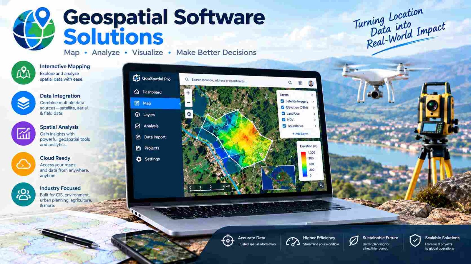
A modern geospatial platform combines several technologies into one system. GIS manages geographic information, satellite imagery provides current visual data, drone photography captures high-resolution images, and spatial analytics identifies patterns and relationships. Interactive dashboards then present the results through easy-to-understand maps and reports.
Real-world applications include planning new roads, monitoring forests, managing agricultural fields, tracking delivery vehicles, mapping flood risks, and helping emergency responders locate incidents faster. The common goal is transforming raw location data into practical knowledge that improves planning and decision-making.
How Geospatial Software Solutions Work?
The workflow behind geospatial software solutions follows a logical process that turns raw geographic information into meaningful business intelligence. Although different platforms offer unique features, most systems follow the same core stages.
The process begins with data collection. Information comes from GPS devices, mobile phones, field surveys, IoT sensors, government datasets, and existing business records. Many organizations also capture precise locations using GNSS technology, which provides accurate positioning across large geographic areas.
Next, satellite imagery and drone mapping add detailed visual information. High-resolution images help engineers monitor construction projects, farmers evaluate crop health, and environmental agencies observe land changes over time. These images are stored alongside spatial information inside specialized spatial databases that organize millions of geographic records efficiently.
Once the data is stored, the GIS engine processes it by cleaning errors, matching coordinate systems, and connecting related datasets. Spatial analysis then identifies patterns such as the shortest delivery route, areas with high customer demand, flood-prone neighborhoods, or infrastructure maintenance priorities.
Finally, the software displays results through interactive maps, charts, and dashboards. Decision-makers can explore information visually, generate reports, and share insights across departments, making geographic data useful for everyday business operations.
Core Features of Geospatial Software Solutions
The strength of geospatial software solutions comes from their wide range of mapping and analytical capabilities. These features help organizations move beyond static maps and create intelligent geographic systems.
Interactive digital mapping allows users to zoom, filter, and customize multiple layers of information on a single map. Spatial analysis tools measure distances, identify geographic relationships, calculate service areas, and detect trends that support strategic planning.
Modern platforms also provide both 2D and 3D visualization. Two-dimensional maps are ideal for everyday planning, while 3D models help architects, engineers, and city planners visualize terrain, buildings, and infrastructure projects more realistically.
Geocoding converts addresses into map coordinates, while reverse geocoding performs the opposite task by identifying addresses from GPS locations. Route optimization helps logistics companies reduce travel time and fuel costs by calculating efficient delivery paths.
Terrain and elevation modeling support flood analysis, mining operations, and infrastructure design. Asset management enables organizations to track equipment, pipelines, utility poles, or public facilities on a live map. Real-time tracking displays moving vehicles or field teams instantly, improving operational visibility.
Heat maps reveal areas with high activity, customer density, or environmental changes. Location intelligence dashboards summarize complex geographic information through visual reports, while mobile GIS applications allow field workers to collect and update data even when working offline. Cloud collaboration ensures teams across multiple locations can work from the same updated geographic database.
Types of Geospatial Software Solutions
Different organizations require different kinds of geospatial software solutions, depending on their size, industry and technical needs.
Desktop GIS Software
Desktop GIS applications are installed on individual computers and are popular among surveyors, planners, researchers, and engineers. They offer advanced editing, detailed cartography, complex spatial analysis, and reliable offline performance. These tools are ideal when high processing power and precision mapping are required.
Cloud-Based GIS Platforms
Cloud GIS platforms operate directly through web browsers without requiring heavy software installation. Teams can access projects from anywhere, collaborate in real time, and benefit from automatic updates. These systems are especially useful for distributed organizations managing multiple offices or remote workers.
Enterprise GIS Solutions
Enterprise platforms are designed for large organizations that manage thousands of users and massive geographic datasets. They provide centralized security, user permissions, scalable infrastructure, and integration with existing business systems such as ERP and CRM platforms.
Mobile Geospatial Applications
Field teams use mobile GIS applications to perform inspections, collect survey data, photograph assets, and update records directly from smartphones or tablets. Offline capabilities ensure productivity even in remote locations without internet access.
Web Mapping Solutions
Web mapping software creates interactive public maps, customer portals, tourism maps, and business locator applications. These solutions make geographic information easily accessible through websites while maintaining centralized data management.
Key Technologies Behind Geospatial Software Solutions
Several advanced technologies work together to make geospatial software solutions powerful and accurate.Geographic Information Systems (GIS) serve as the foundation by organizing and analyzing spatial information. Remote sensing collects Earth data from satellites and aircraft without physical contact, making it valuable for environmental monitoring and disaster assessment.
GNSS and GPS provide accurate positioning for vehicles, smartphones, and surveying equipment. Satellite imagery offers regularly updated views of the Earth’s surface, while drone mapping captures highly detailed aerial photographs for construction, agriculture, and infrastructure projects.LiDAR uses laser pulses to measure elevation and create precise 3D terrain models. This technology is widely used for flood analysis, forestry, and engineering design.
Digital twins create virtual representations of real-world cities, buildings, and infrastructure, allowing planners to simulate future scenarios before making expensive decisions. Artificial Intelligence and Machine Learning analyze enormous spatial datasets to identify patterns, predict maintenance needs, and automate object detection within satellite images.
The Internet of Things (IoT) continuously sends live location data from connected sensors, while spatial databases such as PostgreSQL with PostGIS efficiently manage geographic information. Finally, Web GIS services allow organizations to publish maps securely across browsers and mobile devices.
Industries That Use Geospatial Software Solutions
Nearly every industry benefits from geospatial software solutions because location plays an important role in planning, operations, and customer service.Urban planning departments use GIS to design transportation networks, zoning plans, and smart city infrastructure. Construction companies combine drone imagery with project maps to monitor progress, estimate earthwork, and improve site management. Utility providers map electrical lines, water pipelines, and communication networks for faster maintenance.
In agriculture, farmers analyze soil quality, crop health, irrigation systems, and weather conditions to increase productivity. Environmental organizations monitor forests, wetlands, pollution, and climate-related changes using satellite data and remote sensing technologies.
Mining companies evaluate terrain, mineral exploration sites, and safety conditions through 3D geographic models. Transportation and logistics businesses optimize delivery routes, warehouse locations, and fleet management using live traffic information.
Telecommunication providers plan tower locations based on coverage analysis, while emergency response agencies use real-time maps to coordinate rescue operations during floods, earthquakes, or fires. Real estate professionals evaluate property value by combining demographic and geographic information, and government agencies rely on GIS for land administration, infrastructure planning, taxation, and public services.
Benefits of Using Geospatial Software Solutions
Organizations invest in geospatial software solutions because they deliver measurable improvements across planning, operations, and customer experience.The greatest advantage is better decision-making. When executives view business information on intelligent maps, they can identify opportunities and risks much faster than with spreadsheets alone. Spatial analysis also improves planning by revealing geographic relationships that traditional reports often miss.
Operational efficiency increases through automated mapping, route optimization, and centralized asset management. Field workers spend less time searching for infrastructure, while logistics teams reduce travel distance and fuel expenses. These improvements contribute directly to lower operational costs and higher productivity.
Resource allocation becomes more accurate because managers can visualize demand, workforce distribution, and equipment locations. Real-time monitoring helps organizations respond quickly to changing conditions, whether tracking delivery vehicles or monitoring utility networks.
Geospatial software also strengthens risk management by identifying flood zones, wildfire threats, environmental hazards, and infrastructure vulnerabilities before they become costly problems. Many industries benefit from improved regulatory compliance because geographic records provide detailed documentation for inspections and reporting.Ultimately, customers receive better service through accurate location data, faster deliveries, improved infrastructure maintenance, and more reliable public services.
Best Geospatial Software Solutions in 2026
Several platforms serve different business needs. The best choice depends on your budget, technical requirements, and deployment preferences.
| Software | Best For | Deployment |
| ArcGIS | Enterprise GIS | Cloud & Desktop |
| QGIS | Open-source GIS | Desktop |
| ArcGIS Online | Cloud mapping | SaaS |
| ArcGIS Enterprise | Large organizations | On-premise & Cloud |
| CARTO | Location intelligence | Cloud |
| Google Earth Pro | Visualization | Desktop |
| Maptitude | Business mapping | Desktop |
Enterprise organizations often choose ArcGIS for scalability and security, while QGIS remains a popular free alternative for professionals and researchers. CARTO focuses on business location intelligence, and Google Earth Pro is widely used for visualization and geographic exploration.
Cloud vs Desktop Geospatial Software Solutions
Choosing between cloud and desktop deployment depends on how your organization works.
| Feature | Cloud | Desktop |
| Installation | No installation | Local installation |
| Collaboration | Excellent | Limited |
| Offline Work | Moderate | Excellent |
| Scalability | High | Medium |
| Processing | Server-based | Local computer |
Cloud platforms are ideal for organizations with remote teams because projects stay synchronized automatically. Desktop software offers stronger offline performance and advanced editing for technical specialists working with complex spatial datasets.
Essential Integrations for Geospatial Software Solutions
Modern geospatial software solutions rarely operate alone. Their real value comes from integrating with existing business systems.
ERP integration connects geographic information with finance, inventory, and operations. CRM platforms allow businesses to analyze customer locations and improve sales territories. CAD and BIM workflows help architects and engineers combine design drawings with geographic context during infrastructure projects.
SQL databases and PostgreSQL with PostGIS provide reliable storage for large spatial datasets, while REST APIs enable custom applications to exchange geographic information securely. Web services such as WMS and WFS make maps available across different GIS platforms, ensuring interoperability between organizations.
IoT sensors continuously update infrastructure status, environmental conditions, or vehicle locations, while business intelligence tools combine geographic and financial data to create powerful executive dashboards. These integrations create a complete ecosystem where location becomes part of everyday business intelligence.
How to Choose the Right Geospatial Software Solution?
Selecting the right geospatial software solution begins with understanding your organization’s goals. A small surveying company has different needs than a nationwide utility provider, so choosing software should focus on practical requirements rather than the number of features.
Start by evaluating your business size, industry, and available budget. Decide whether cloud deployment offers better collaboration or whether on-premise infrastructure provides stronger control and security. Consider the complexity of your spatial analysis, the need for 3D visualization, mobile field data collection, and integration with existing ERP or CAD systems.
Security, vendor support, training resources, and future scalability are equally important. The ideal platform should solve today’s challenges while supporting long-term growth without requiring expensive system replacement.
Common Challenges and Their Solutions
Like any enterprise technology, geospatial software solutions present challenges that organizations must manage carefully.Large geographic datasets can reduce performance, but cloud infrastructure and optimized spatial databases improve processing speed. Data accuracy depends on reliable GPS collection, consistent field procedures, and regular quality checks. Coordinate system differences often cause mapping errors, so organizations should standardize projection settings across projects.
Integration difficulties can be minimized by using open standards and REST APIs. User training is essential because even powerful GIS software delivers limited value without skilled operators. Licensing costs can be controlled by matching software editions to actual business needs, and strong encryption, user permissions, and backup strategies protect sensitive geographic information from security risks.
Future Trends in Geospatial Software Solutions
The future of geospatial software solutions is centered on automation, intelligence, and real-time decision-making. Artificial Intelligence is making spatial analysis faster by automatically detecting roads, buildings, vegetation, and infrastructure within aerial imagery.
Digital twins will allow cities and industrial facilities to simulate construction, traffic, and maintenance scenarios before implementing physical changes. Real-time IoT mapping will connect millions of sensors to live geographic dashboards, providing continuous visibility into utilities, transportation, and environmental systems.
Cloud-native GIS platforms will continue improving collaboration, while edge computing will process geographic information closer to connected devices for faster response times. Drone automation and autonomous infrastructure monitoring will reduce manual inspections and improve safety, making geospatial technology even more valuable across both public and private sectors.
Frequently Asked Questions
1. Do geospatial software solutions require internet access?
Not always. Many desktop GIS and mobile applications support offline mapping and data collection, then synchronize information once an internet connection is available.
2. Can small businesses benefit from geospatial software?
Yes. Small businesses use geospatial tools for customer mapping, delivery planning, sales territories, property management, and local market analysis without needing enterprise-level infrastructure.
3. What is the difference between spatial data and location data?
Location data identifies a position, while spatial data includes both the location and the geographic relationships between people, places, objects, and environments.
4. Is drone mapping compatible with GIS software?
Yes. Most modern GIS platforms can import drone images, orthomosaics, elevation models, and 3D terrain data for analysis and project planning.
5. Why are spatial databases important in GIS?
Spatial databases store geographic information efficiently, allowing organizations to perform fast searches, distance calculations, map rendering, and large-scale spatial analysis with high accuracy.
Conclusion
Geospatial software solutions have become essential tools for organizations that depend on accurate location information. By combining GIS, GPS, satellite imagery, spatial analytics, and cloud technology, these platforms transform raw geographic data into meaningful business intelligence.
Whether you work in construction, agriculture, logistics, utilities, or government, the right geospatial solution can improve planning, reduce costs, strengthen decision-making, and increase operational efficiency. As AI, digital twins, and real-time mapping continue to evolve, geospatial technology will play an even greater role in creating smarter businesses and more connected communities.